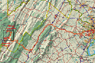
Overview: D.C. to camp location
|
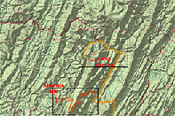
Camp and alternate sites
|
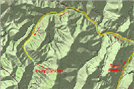
Camp closeup
|
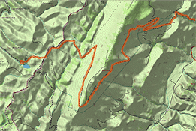
Alternate closeup
Maps from Delorme TopoUSA
|
|
Welcome to the Falls of Seneca!
It's actually quite easy to get there. Take 66 West from D.C. to 81 South after you pass Front Royal. (amended: shorter but you must pay attention to the signs!) You can take Route 55 W from Strasburg, VA, which snakes all around until it gets to Seneca Rocks. Follow the rest of the directions from Seneca Rocks. See purple line for 55W One of the first Harrisonburg exits is for Route 33 West, take it. Continue on past the West Virginia border (It's all detailed on map 1). It snakes around all over the place once it crosses the border, but the general direction you want to go is
toward Seneca Rocks. This is a very pretty place and certainly worth a visit. At Seneca Rocks, 33 again travels mainly west, and you pass the village of Onego (see also map 2). About 2 miles on the left is CR (County Road) 33/3, also called White's Run Road (GPS: N38°51.84' x W79°27.28'). This is where it gets tricky.
Take a left, and soon after, take the first fork to the right. Don't take CR 7/1 (Strader's Run Rd.), to the left. Look at map 3 carefully. (Amended after being there) I believe it's almost exactly 1.6 miles down the road, to your left, where the camp entrance is located. Vehicles lower to the ground can park on the grass just inside the entrance, higher clearance vehicles can go all the way in. If you're the first one there, it's a camp with the sign "Golden's Glen" on a small hillock (see this picture). It's about a six mile walk in from the red X (at GPS: N38°49.25' x W79°29.59') to the falls we intended to see on 8/31/03. Unfortunately, there's an inholding (private property) in the middle of the hike, and we're not sure how friendly the owners are. Definitely keep dogs leashed on the property, but trespassing is discouraged. It's evident that the area is regularly visited.
Alternate location, Spruce Knob Lake Campground :from D.C. (see link below, too) From Route 33, after passing Judy Gap (see map 4), and before you hit the village of Riverton, take a left on County Road 33/4 (Briery Gap Road) to Simoda. At Simoda, about 2 1/2 miles away, follow FR (Forest Road) 112 up over Spruce Knob (the entrance for Spruce Knob lookout will be on your right), and back down into the valley. Eventually there is a right on Forest Road 1, which leads to Spruce Knob Lake.
From Intersection 33 and 33 33/3/White's Run Rd: Take a right onto 33, and continue to Seneca Rocks. Follow 33 as it makes a right (southbound) turn. After the village of Riverton, and before Judy Gap, take another right up County Road 33/4 (Briery Gap Road) to Simoda (See map 4). At Simoda, about 2 1/2 miles away, follow FR (Forest Road) 112 up over Spruce Knob (the entrance for Spruce Knob lookout will be on your right), and back down into the valley. Eventually there is a right on Forest Road 1, which leads to Spruce Knob Lake (at GPS: N38°42.254' x W79°35.392').
[printer-friendly version]
|
|


